PRODUCT DETAILS
Note
Slamtec Mapper M2M1 is the Pro version of Slamtec Mapper M1M1, The main difference is that the Pro version M2M1 can be used in most industry scenarios, while the previous version is mostly used by developers.
Key Features
- Large Scenarios and High-quality Mapping
- Industry grade LiDAR, 2 times detecting range further than M1M1, and higher sample rate.
- Plug and play, without any external dependence
- Can be used as a mapper as well as a laser range scanner
- Connected with WiFi or Ethernet, easy communication
- Fully Compatible with ROS, Easy Data Analysis
- Strong stability: work well in fast speed and in the tilting scenarios
Description
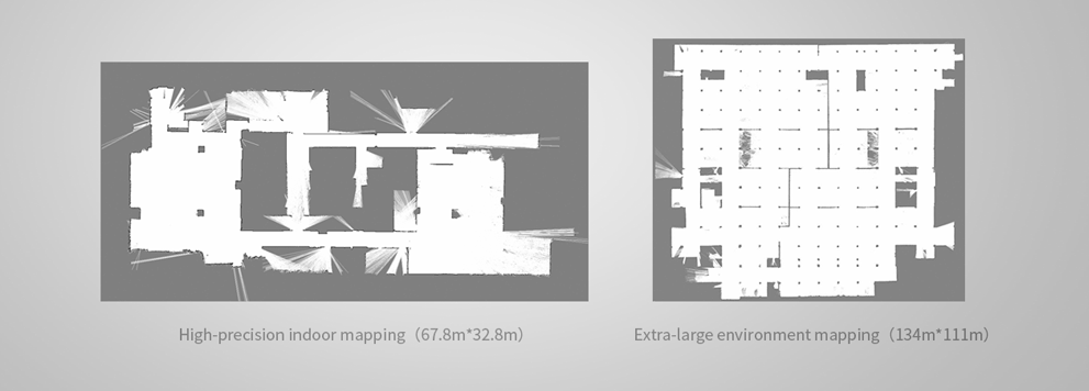
Slamtec Mapper M2M1 is an industrial-grade LiDAR. Different from the normal LiDAR, M2M1 has the ability to work in some severe surroundings. SLAMTEC Mapper uses high-performance SLAM map optimization engine and SharpEdge fine-mapping technology, which can actively detect and correct closed-loop, and achieve 100,000 square meters high-precision map and pose. SLAMTEC Mapper can work without additional sensors or data input. Because of the built-in 9-DOF inertial navigation system, SLAMTEC Mapper in the hand-held mapping mode can work normally in a fluctuating environment with inclination, to ensure the best map data quality.
SLAMTEC Mapper provides a complete SDK development kit, mobile phone, and PC-side evaluation tools to facilitate users to expand development and data acquisition. At the same time, combined with the supporting ROS driver, the generated map and pose data can be directly used in the ROS environment, which is fully compatible.
Large Scenarios and High-quality Mapping
Slamtec Mapper adopts SLAMTEC third-generation high-performance SLAM graph optimization engine and SharpEdge mapping technology to realize a high accurate thousand-square-meter map building and real-time localization, and it can actively detect the closed-loop and correct map. The mapper is an ideal choice for users to realize mapping and re-localization in various complicated scenarios and output map and localization data that meets users’ expectations.

Tilting Compensation and Fast Moving
With a built-in inertial navigation system with nine degrees of freedom, Slamtec Mapper can work properly in tilting and shaky hand-held mode and ensure an excellent map data quality. In addition, it supports to move fast with a maximum speed of 2m/s.

Indoor and Outdoor Availability
Whether in a complicated indoor environment or an outdoor environment with direct daylight, Slamtec Mapper shows a good performance in mapping and localization in those complicated scenarios.

Fully Compatible with ROS, Easy Data Analysis
Slamtec Mapper provides completed cross-platform SDK and tools both on the phone and PC side for users to evaluate, develop and use. Through a matched ROS driver, you can integrate the generated map and localization data into the ROS environment seamlessly.

More Than A Mapper
Slamtec Mapper is not only a mapper for mapping and localization, but you can also use it directly as a laser range scanner. Via SDK or ROS node, you can easily put the data of the laser range scanner into the user’s current system.

Built-in WIFI, Ethernet port, Easy communication
With built-in access point and station mode WiFi as well as 100M Ethernet port, you can get the real-time map and localization data generated by Slamtec Mapper through the designed mobile application.

Specification Compared with Slamtec Mapper M1M1
| Model | M1M1 | M2M1 |
|---|---|---|
| Distance Range | 20m | 40m |
| Sample Rate | 7K | 9.2K |
| Max Mapping Area | 300m x 300m | 300m x 300m |
| Resolution | 5cm | 5cm |
| Max Moving Speed | 1m/s | 2m/s |
| Max Rotate Speed | TBD | TBD |
| Re-localization Accuracy | 0.02m | 0.02m |
| Map Optimization Duration | About 1 hour | About 1 hour |
| Slope Angle | 3 | 3 |
| Data Refresh Rate | 8Hz | 10Hz |
Comparing Different RPLiDARs
For your convenience, we made a table comparing different RPLiDARs so you can easily pick one that suits your project!
| Item | Measurement Performance | ||||
|---|---|---|---|---|---|
| Distance Range | Measurement Resolution | Angular Resolution | Sample Rate | Working Environment | |
| RPLIDAR A1M8-R6 | 0.15m 12m | 0.5 mm | 1 | 2000-8000 Hz | Indoor |
| <1% of actual distance * | |||||
| RPLIDAR A2M6 | 0.2m C 18m | <0.5 mm | 0.9 | 2000-8000 Hz | Indoor |
| <1% of actual distance * | |||||
| RPLIDAR A2M8 | 0.15m 12m | <0.5 mm | 0.9 | 2000-8000 Hz | Indoor |
| <1% of actual distance * | |||||
| RPLIDAR A3M1 | White objects: 25 m | 0.225 | 16 kHz or 10 kHz | Indoor & Outdoor | |
| Black objects: 10 m | |||||
| RPLIDAR S1 | White Objects: 40m | 3cm | 0.313-0.587 | 9200 Hz | Indoor& Outdoor |
| Black Objects: 10m | |||||
| RPLIDAR S2 | White Objects: 30m | 5cm | 0.12 | 32 kHz | Indoor& Outdoor |
| Black Objects: 10m | |||||
| SLAMTEC MAPPER M1M1 | 20m | 5cm | 7000 Hz | Indoor & Outdoor | |
| SLAMTEC MAPPER M2M1 Pro | 40m | 5cm | 9200Hz | Indoor & Outdoor | |
Dimensions

Part List
- 1xSlamtec Mapper M2M1 Pro Edition – Laser Mapping Sensor


